![]() Marc is 07/07/2025 06:55 5 min
Marc is 07/07/2025 06:55 5 min
A few days ago, we announced a wet and fresh start to the week in the Paris region, But we also mentioned a probable heat wave, or even scorching temperatures in Paris and Île-de-France from the weekend.
If there is no doubt that it is the freshness that dominates this Monday, More uncertainties hover over what will really happen at the weekend. If the sun and the heat should gradually impose itself from Wednesday, It remains to be refined to what level the temperatures will climb at the end of the week, And what will be the evolution of time to close on the long weekend of July 14.
Indeed, a cold drop could destabilize the air mass, and the Atlantic disturbances could also change forecasts. In any case, sun and heat should impose itself well at the end of the week, But at this stage, there is no longer a question of temperatures above 35 ° C in Île-de-France (except perhaps from July 14).
Freshness to start the week
These next 36 hours promise to be wet and very cool for the season in Île-de-France, With sometimes supported showers. It will be necessary to wait until Tuesday afternoon to find more beautiful clearings in the Paris region.
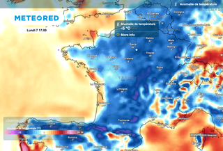
 A wet Monday in Île-de-France.
 As the above card shows, showers should not save anyone in Île-de-France. They can locally be supported and bring significantly, significant rain, Which is a good thing given the drought of the soils at the start of this summer. These rains are therefore welcome at this time of the year.
Self -feeling fall
Under the effect of the northwest wind and the arrival of this mass of air of polar origin, Temperatures promise to be fresh, worthy of early October, And will sometimes find it difficult to exceed 20 degrees at the best time of the day.
 Fallow for this start of the week in the Paris region.
 As shown in the card above, the expected temperatures will sometimes be 4 to 6 degrees below seasonal norms.
After a morning of Tuesday still wet with the passage of showers, Beautiful clearings should end up returning in the afternoon, But temperatures will still remain cool for the season.
Back to summer Wednesday
From Wednesday, The anticyclone will be essential in the region, with the return of sunny conditions. Temperatures will take advantage of this to continue their ascent, with a good average of 25 degrees in the region.

The heat should be more marked between the days of Thursday and Friday, With 27 ° C planned in Paris Thursday afternoon and nearly 30 degrees on Friday afternoon.
 Nearly 30 degrees Friday afternoon in the Paris region.
 It could still ride a notch at the start of the extended weekend, between Saturday 12 and Sunday 13 July, With values that should reach 31 to 32 degrees in Île-de-France. This heat could become even more marked for Monday July 14, With nearly 35 degrees, but this trend requires being confirmed in the coming days.
These very strong heat could then extend, But the models still diverge a lot on this deadline. We will have the opportunity to return to these forecasts during the week.